7.14.2011

Urbanism and Iconography


Hey all,

I wanted to post my notes from the precedent study presentations, in case anyone wanted to use them. Find your city!

I've always been fascinated by the intersection of the physical and temporal, and this summer program has me thinking a lot about iconography. Our built environment is full of these little symbols, to which we become accustomed and for which we sometimes even find an affinity. A great example are the "Ampelmännchen" in East Berlin, which became a serious source of cultural-historical pride after the reunification of Germany, and remain in use in East Berlin today.

Here's a great blog post about the simple iconography of way-finding symbols in transit systems around the world. These universal images can transcend the boundaries of language and culture.

7.11.2011

"Greening the Ghetto"

I wanted to share this TED Talk that I came across over the weekend. Majora Carter shares the story of her activism work in the South Bronx and demonstrates how powerful sustainable planning can be in attempting to correct environmental injustices.

This talk reminded me a lot of the Planner's Triangle that Campbell discusses in his "Green Cities, Growing Cities, Just Cities?" article, where as planners, we must address the conflict of three competing interests: Economic Development, Social Justice/Equity, and Environmental Protection. I found Carter's story to be an inspiring example of what planning can accomplish when a balance of the three is found. Certainly, her work really brought to life a lot of issues of public heath and environmental equity for me and it's amazing to see how sustainability and planning can go hand in hand to enormously improve urban spaces for the people who live in them.

Map Your Solar Potential - NYC Solar Map


The New York City Solar America City Partnership, led by Sustainable CUNY, is proud to welcome you to the New York City Solar Map. This map shows existing solar PV and solar thermal installations in NYC and gives an estimate of solar PV potential for every rooftop in the five boroughs.

The New York City Solar Map is a tool that all New Yorkers can use learn about the potential for solar on their buildings and across the city. It also provides practical information and steps for installing solar. Here is the related NY Times article.

These are the kinds of open source tools cities should fund for technological innovation to make sustainable endeavors as easy as possible for residents. Check it out!

Image from NYT.

7.10.2011

Its all in the Packaging: Move over Whole Foods.


Austin, TX will boast a zero waste package-free grocery store cleverly named in.gredients in 2011. Creative business models like this are an excellent way for businesses to help communities realize their specific climate action plan goals. Berkeley Bowl what do you think??? Watch the video for Austin's new grocery store below.


Credits: Image and video from www.in.gredients.com


Documentary Recommendation: Are you sustainability?


I highly recommend Tom Shadyac's recent documentary. The truth of who we are is that we are because we belong!!


Credits: Image of Delta from __http://www.acadia.org/acadia2008/wp-content/uploads/2008/08/060_001.jpg___. Video from Youtube

Letting go of a bright idea? Light Bulb Debates


It seems some politicians in Washington are seeking to make it difficult for local municipalities to enforce efficiency standards for lightbulbs. Read the article here...

Credits: Image of lightbulb from Science Photo Library.

Understanding the True Cost of Gasoline


Credits: Image of Guzzler from Nicholson. Video of The Price of Gas from Youtube.

Planning Games

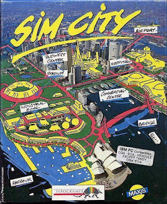
With the success of SimCity and the omnipresence of virtual technologies,
it is interesting to showcase the original game cover from 1989.

As we start [IN]City and meet others in the program, one common question that comes up is, "how did you get interested in city planning?" For me, it always comes back to my days sitting on the computer building multitudes of cities on none other than good ole' SimCity. I assume probably most of you have played it a few times.

Because of that game, wherever I traveled I tried to come back and build. It was a game that could last minutes until I crushed a city with aliens or tornadoes, or weeks as I slowly built up its wealth and population on the slowest time setting.

But back then, it was never about city planning. I never really even knew what city planning was until college. But as our world becomes more digital, computer games powerful enough to model traffic flows, wealth shifts, and demographic trends like SimCity (4 I think is the latest one?) become valuable tools to teach and inspire generations of planners to come.


While these types of games are extremely valuable, they could also constrain thinking, which is what I've been thinking about lately too. In SimCity, although you could potentially start by doing anything, the best methods were to begin with plotting gridded zones of residential, commercial, and industrial. Then, you had to make sure they were all connected using roads. Mass transit on the scale of trains and subways really didn't become a factor until later on when it became affordable. The game, as advanced, inspiring, and educational as it was, really forced you to look at developing cities in only a few ways.

So, what could be the role of these games for the future? Will they continue to just be entertainment and only inspirational here and there, or could they become powerful enough to teach a higher level of planning early on? Also, how did the rest of you get interested in city planning?

Image from weblogs.asp.net

7.08.2011

Another One Rides the Bus


Right now I'm sitting at Peet's Coffee & Tea at Telegraph and Dwight. It's 5:00 on a Friday. Rush hour. Looking out the window, I see two buses go through the intersection almost simultaneously, the 1 and the 1R. One is half full, and the other is nearly empty. Cars are backed up Dwight as far as the eye can see. And I ask myself a question I've wondered a thousand times.

Why don't more people ride the bus?

Personally, I like riding the bus. While trains are faster for certain kinds of trips, they don't offer the same kind of experience the bus offers. Trains are boring to me. They're either underground or way above ground, and I like the surface experience the bus offers. And yes, I realize that not everyone likes that experience. Buses have a reputation for attracting "the crazies." But I think you get crazy people on trains too, so I think that stigma is unjustified. And it's more than made up for by putting you in direct contact with the life of the city. I took the F bus across the Bay Bridge last night, and it was spectacular. Granted, I'd never been across the Bay Bridge before, but I don't think anyone could ignore the urban beauty of the San Francisco skyline at dusk, no matter how many times they see it. I wouldn't have been able to fully admire this view if I was driving a car, and I wouldn't have seen it at all if I had taken the train.


Buses are also cheaper. They're cheaper to build, they're cheaper to buy, and they're cheaper to ride. They're more expensive to operate on a year-by-year basis than light and heavy rail trains, but the enormous up-front investment required to build a rail system makes a comprehensive bus system by far the more sensible choice. I'm going to talk about the debate between bus and light rail in another post, but suffice it to say that expanding bus service makes more sense than building a light rail system when your resources are limited because you don't have to build new infrastructure: the roads are already there.

So, again, why don't people ride the bus? It's an hour later here at Dwight and Telegraph, and I've seen a lot of people. Most were walking, many were in cars, some were on bicycles, and a few were on scooters and skateboards. Dozens of buses have gone by in this hour. They were definitely in use, but none of them were standing room only. People obviously need to get places at 6:00 on a Friday afternoon, and it's their prerogative to choose how to get where they need to go. I just wish more people would see what I see when I look at the bus.

Credits: Image of Buses from SF Gate, Image of San Francisco Bay Bridge from Pulsar Wallpaper.

Sweet TED Talk: Building a Park in the Sky

I really enjoyed this talk.


- jo-z

7.07.2011

Is Money Enough of a Mandate?

Image of the Wuhan Ring Road from the New York Times.

Although much of the Western world is still recovering from its easy debt habit and the building boom of the mid-aughts, China is in the middle of an urban boom, which includes ambitious megacity projects to link cities and brand new cities with plenty of shiny new buildings, but few residents.

This article from yesterday's New York Times takes a closer look at what appears to be a precarious debt scenario:

As municipal projects play out across China, spending on so-called fixed-asset investment — a crucial measure of building that is heavily weighted toward government and real estate projects — is now equal to nearly 70 percent of the nation’s gross domestic product. It is a ratio that no other large nation has approached in modern times.

Even Japan, at the peak of its building boom in the 1980s, reached only about 35 percent, and the figure has hovered around 20 percent for decades in the United States.

While this article touches upon many interesting questions, including how swiftly the Chinese government can turn a project from a sketch into a major roadway, I'm most concerned with the question of money. Many times, developments in both the U.S. and China happen because the money is available. Should we build things just because the money is there?

As an aside, China is also building these projects when it may soon face the 4-2-1 demographic timebomb, where the one child policy has lead to families with an inverted pyramid of four grandparents and two parents, all on the shoulders of one child.

7.06.2011

Thinking about Zotero

Become a Zotero Person?

Putting together a bibliography at the end-phase of writing a paper was always a hassle, so I was delighted to start using EndNote years ago. I was even happier with Zotero, because it is free and works on multiple operating systems--anywhere that Firefox can run, Zotero can be installed as a plug-in to Firefox.

For those who don't like using Firefox, the good news is that the Zotero developers are hashing out a stand-alone program that can work with Firefox, Chrome, or Safari. At this point Zotero standalone is in "alpha" phase, meaning that it is still being tested for bugs. I have found that it works fine, but use at your own peril.

The other thing that I like is that Zotero provides some free disk space so that you can back up your bibliographic database to "the cloud." I recently reformatted my hard drive. When I reinstalled the OS, the apps, and the Zotero plugin, I could just sync my local database with the one stored at my online Zotero account.

Zotero and EndNote exemplify one of the useful traits of databases: each reference is a record with multiple fields including the author's last and first names; year of publication; title; publisher; ISBN; and comments. Output from these DBs can be formatted in many different ways corresponding with different bibliographic styles: Chicago, MLA, American Psychological Association, etc.

You can also add comments to each record, which will help you in the future. You are likely to refer to favorite publications repeatedly over time, so it is worth investing in a personal database of key references.

Sleutherama - Online access to journals


The Bibliotheque Nationale de France by Dominque Perrault was one of the crowning architectural jewels of Francois Miterrand’s socialist government during the 1980’s and90’s. One of the most celebrated libraries in the world, it does not carry out a wireless network.

Since you are registered in the Berkeley system for the summer, you get online access toelectronic versions of major research journals--even from your own computer at home!

To make this work, you need to set up Proxy Server access in your web browser. Once you have done this, any time you encounter a login gateway, you have to enter your CalNet username and password (these are different from your Student ID number, and different from your login to the computer lab accounts within Wurster).Then, you go to the UCB Library homepage and you will find link to finding and accessing electronic journals, such as "E-journal titles A-Z”.

A street view of a monument to german literary giants in Berlin, Germany

Now let me step back for a moment. This is the way to actually get the articles, but how do you search an issue in peer-reviewed journals (i.e. "critiques of Climate Action Plans--California")?
First, there is Google Scholar, which focuses on peer-reviewed publications.Second, there are various electronic library catalogs, such as Berkeley's OskiCat.

Happy sleuthing!

[In]City software thoughts


You have heard the official recommendation for software for this program, so this post is about free and open-source alternatives to the commercial software.

1. Quantum GIS (QGIS). Like ARC GIS, QGIS creates and edits shapefiles as its standard format, so it is highly interoperable with ESRI's ARC GIS. QGIS is not only free, but it also runs natively on Windows, Mac, and Linux. The core program is small, lightweight, and intuitive, but it also plugs into GRASS, which is a collection of 300+ tools that were written as a GIS program for the Army Corps of Engineers in the 1908s.

2. The GIMP (Graphic Image Manipulation Program). This edits "raster" images such as JPEG, TIFF, GIF, and PNG. It has the same core tools as Photoshop.

3. LibreOffice. This is a full office suite including a word processor (like Word), spreadsheet (like Excel), presentation (like PowerPoint), drawing program, and database program (like FileMaker or Access).

Question #1: Can you really get work done with the free software? Yes, I wrote my dissertation, edited and included several hundred images, and built a GIS model of Kabul with these programs. I used the Ubuntu Linux operating system, which I do not recommend (yet), because it takes a bit of work to get used to the problem-solving culture of Linux.

Question #2: What are the trade-offs? If you plan to work in an office that uses commercial GIS software, you should only use the ESRI software. Why? because QGIS and ARC GIS may have the same tools, but they are in different menu-locations on each program. The amount of time spent learning a different interface can be expensive. On the other hand, if you already understand GIS, but you only use it occasionally, or you want to experiment with it but you aren't sure if you really want to commit to it, QGIS is always there. And once you learn the core concepts (georeferencing, linking spatial entities to database records, geoprocessing), both programs do the same underlying thing. The same trade-offs apply to the GIMP and Libre Office. The LibreOffice interface looks like the Microsoft Office interface pre-2003, so it is actually easier for me to use LibreOffice Writer than a recent version of MS Word.

One other consideration: while you are participating in the [In]City program, you can come to me for support questions. So if you have ever wanted to dip your toe into the open-source pool, just ask Pietro.